GPS Map Camera - GeoTag 2.1.1
Free Version
Publisher Description
GPS Map Camera - GeoTag - GPS geodata: take geodata, fake, edit or delete GPS exif on smartphone camera!
If GeoTag runs properly, please, put a 5* rating and a comment with wish-features - you will help me to perfect the app! https://www.facebook.com/geotag.android/
GeoTag app was created to geotag (add exif data) the smartphone photos with high accuracy (while unable to sync with DSLR cams, GeoTag can add and edit geotags to any offline images stored on your smartphone). This geotagging app allows:
- show and share your current GPS location (and show all enabled geodata - see Screen Settings to set defaults);
- take photos and video while displaying GPS location and accuracy on the screen,
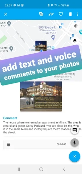
- add text and voice notes to photos (available from Image mode - tap a photo you want to edit);
- display your photos with geotags on the map (view your photos in a geoalbum);
- share photos;
- export geodata as KML, CSV or XLS files;
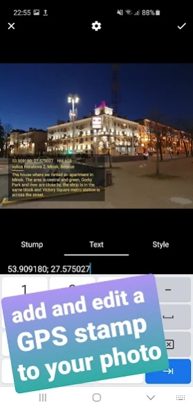
- add and edit customized geostamps / timestamps to images and videos:
- edit the GPS coordinates and other geodata of the photo, fake photo GPS.
With GeoTag you can accomplish the following:
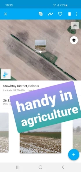
- accumulate geodata in agriculture, which is essential in farming;
- take, edit (fake) GPS data of a picture of your phone camera for private use;
- take a photo with a geotag of a fallen tree, pothole or other everyday hazard you want to report;
- geotag a car that was parked against the rules;
- in real estate: photograph a property on sale to make a PDF report and share with your friend...
Please, note that the time required to obtain GPS coordinates with your smartphone – normally 1-2 minutes - depends on weather, network coverage and other factors like nearby trees, buildings and simply being outdoors. Using the geolocation function of your device along with the camera drains the phone battery.
How GeoTag works in detail:
GeoTag can be used outdoors (using indoors reduces GPS accuracy) on smartphones that support location to take pictures with GPS exif data and share them. With GeoTag on your smartphone you can:
in Camera Mode (you enter this mode when you launch the app):
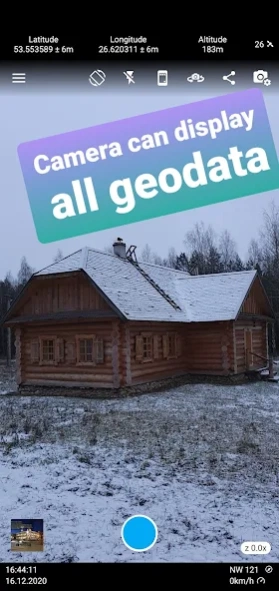
- tune the settings to be displayed on the screen (coordinates, time, address, etc.)
- take pictures while displaying real time coordinates, altitude and accuracy of your location;
- geotag pictures - save your coordinates, weather, address, date / time of taking pictures as exif;
- share your picture or geodata only (coordinates, etc.);
- jump to the last taken image to enter Image Mode
in Image Mode:
- view images, their coordinates and location on the map (maps: satellite, standard);
- swipe between images from the last taken one to view or delete them and check their map location;
- add a geostamp / timestamp to any image on any spot;
- choose Edit info to edit azimuth and other geodata;
- choose color / size / transparency of the geostamp / timestamp;
- export exif as kml file;
- add a text or voice comment (please note, that while a text comment becomes a part of the image file stored in exif data and can be shared, a voice note is not added to the file and cannot be shared along with it)
- images can be shared via Picasa, Google Drive … keeping exif data
- long-tap an image icon on map to edit location and azimuth.
in Gallery Mode:
- arrange images by name / time of creation / distance;
- choose a folder to view PDF reports;
- choose a folder on your camera to view images on the map;
- short-tap an image to enter Image Mode.
Share your ideas through Feedback section!
About GPS Map Camera - GeoTag
GPS Map Camera - GeoTag is a free app for Android published in the Screen Capture list of apps, part of Graphic Apps.
The company that develops GPS Map Camera - GeoTag is Prometheus Interactive LLC. The latest version released by its developer is 2.1.1.
To install GPS Map Camera - GeoTag on your Android device, just click the green Continue To App button above to start the installation process. The app is listed on our website since 2024-03-21 and was downloaded 22 times. We have already checked if the download link is safe, however for your own protection we recommend that you scan the downloaded app with your antivirus. Your antivirus may detect the GPS Map Camera - GeoTag as malware as malware if the download link to travel.minskguide.geotag is broken.
How to install GPS Map Camera - GeoTag on your Android device:
- Click on the Continue To App button on our website. This will redirect you to Google Play.
- Once the GPS Map Camera - GeoTag is shown in the Google Play listing of your Android device, you can start its download and installation. Tap on the Install button located below the search bar and to the right of the app icon.
- A pop-up window with the permissions required by GPS Map Camera - GeoTag will be shown. Click on Accept to continue the process.
- GPS Map Camera - GeoTag will be downloaded onto your device, displaying a progress. Once the download completes, the installation will start and you'll get a notification after the installation is finished.
